The thing about Monument Loop is that nobody really calls it that.
I’ve driven this stretch of Utah dirt maybe a dozen times now, and every single person I’ve met out there—photographers at dawn, Jeep groups from Colorado, that one couple from Belgium who’d somehow ended up there with a rental Kia—they all call it something different. Valley of the Gods Road. The Mexican Hat scenic route. That bumpy thing between the highway and nowhere. The official name, Monument Loop, feels like something a Bureau of Land Management employee came up with during a very boring Tuesday afternoon meeting, and honestly, it probably was. But here’s the thing: whatever you call it, this 17-mile ribbon of washboarded clay and sandstone is one of those places that recalibrates your understanding of what landscape can do to your nervous system. It’s not grand in the Zion way, not precious like Arches. It’s vast and indifferent and weirdly intimate all at once, like the desert decided to show you its diary but didn’t bother editing first.
Why the Road Itself Matters More Than You’d Think (And Why Your Rental Agreement Definitely Says You Can’t Drive It)
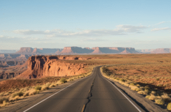
The road is unpaved. Let me be clear about that upfront because I’ve seen the aftermath of optimism meeting reality out here. Seventeen miles of dirt that ranges from pretty okay to oh-god-why-did-I-think-this-was-fine, depending entirely on when it last rained. After a storm, the clay turns to something like half-set concrete. Your vehicle will slide. You will question decisions. But most of the time—say, 70 percent of the year, give or take—it’s passable in a regular car if you go slow and don’t panic when the washboard rattles your dental fillings loose.
I used to think you needed a high-clearance 4×4 for this. Turns out that’s only sort of true. What you actually need is patience and a willingness to accept that your car will get dirty in ways that make car wash employees sigh audibly.
The Valley of the Gods Section Where Everything Gets Weirdly Quiet
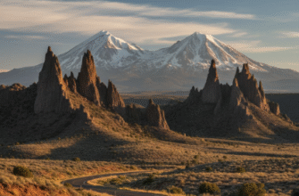
About six miles in from the Mexican Hat side, the road drops into the valley proper and—wait, maybe it’s seven miles, I should’ve checked my notes—anyway, the formations start crowding in. Red sandstone spires, some skinny as church steeples, some squat and brooding like they’re mad about erosion. The Navajo Sandstone here is roughly 200 million years old, deposited when this whole area was a Sahara-scale dune field. Which is wild to think about: these monuments are fossilized deserts of an even older desert. Deserts all the way down.
The silence out here has texture. No cell service, obviously. Often no other cars for hours. Just wind and the occasional raven making that guttural croak that sounds vaguely judgmental. I once sat on a rock for forty minutes just listening, and the only human-made sound was a distant plane, probably headed to Phoenix.
Photography people love this spot, especially the formation called Rooster Butte, though I’ve also heard it called Setting Hen. The light at sunrise does this thing where it ignites the red rock from within, all that iron oxide glowing like embers, and if you’re into that sort of thing—I guess I am now, which is embarrassing—it’ll rewire your brain a little.
How Mexican Hat (The Town and The Rock) Plays Into All This
Mexican Hat, the town, has maybe 31 permanent residents. The rock formation it’s named after genuinely does look like a sombrero balanced on a pedestal, which is either a remarkable coincidence of erosion or proof that the universe has a sense of humor. The town itself is basically a gas station, a motel, and a diner that serves surprisingly decent Navajo tacos. It sits right on the San Juan River, and it’s the eastern entry point to Monument Loop if you’re coming from Monument Valley.
Here’s what nobody tells you: Mexican Hat is also where you realize you’re genuinely in the middle of something enormous and unpopulated. The nearest Starbucks is 87 miles away. The nearest trauma center is even farther. This isn’t a criticism—it’s just the geography asserting itself.
When to Drive It and What’ll Probably Go Wrong (In a Manageable Way)
Spring and fall are ideal. Summer’s brutal—110°F in the shade, except there’s no shade. Winter can dump snow or ice on the road, which turns the whole thing into a definitely-don’t situation. I drove it once in late October and had the entire loop to myself for three hours, which felt both magnificent and vaguely apocalyptic, like I was the last person who’d bothered to show up.
Things that will happen: dust. So much dust. Your water bottle will taste like it. Your sinuses will know about it for days. Also, the washboard sections will make your car sound like it’s disassembling itself in real time. It’s not. Probably. And if you’re there in summer, the heat will make you reconsider your life choices around mile nine, when you’re equidistant from both ends and the AC is losing the battle against thermodynamics. But that’s also kind of the point, I think. The difficulty is part of what makes it feel earned.