
When the Pavement Ends and Your GPS Starts Lying to You
I’ve driven the Sawtooth Scenic Byway three times now, and each time I swear I’ll remember to fill up in Stanley before heading out.
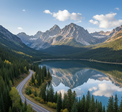
Here’s the thing about Idaho’s Highway 75—it doesn’t care about your schedule or your fuel gauge. The 115-mile stretch from Shoshone to Stanley cuts through some of the most indifferent geology in the Lower 48, where the Sawtooth Range juts up like broken teeth against a sky that feels, I don’t know, somehow closer than it should be. The road itself was designated a National Scenic Byway in 1992, though locals had been driving it for decades before anyone thought to make it official. You’ll climb from roughly 4,800 feet to over 8,700 feet at Galena Summit, and the whole time your ears are popping, you’re passing these alpine lakes—Redfish, Alturas, Pettit—that look like someone spilled liquid sapphire across the valley floor. Geologists will tell you the Sawtooths are young mountains, maybe 50 to 60 million years old, give or take, formed by a massive granitic batholith that got shoved up and then carved out by glaciers during the Pleistocene. The lakes? They’re basically glacier scars filled with snowmelt.
I used to think wilderness meant empty, but the Sawtooth Wilderness Area—which sprawls across 217,000 acres adjacent to the byway—is crowded with life if you know where to look. Bighorn sheep on the ridgelines. Cutthroat trout in the streams. The occasional mountain goat that stares at you like you’re the intruder, which, honestly, you are.
The Part Where You Realize Your Car Might Not Make It
Anyway, the drive isn’t technically difficult—it’s paved the whole way, two lanes mostly—but that doesn’t mean it’s easy.
Galena Summit hits you around mile 60, and if you’re heading north in late May or early June, there’s still snow up there, these crusty gray piles shoved to the roadside by plows. The overlook at the summit is one of those places where you feel obligated to stop and take a photo, even though your phone camera will absolutely fail to capture the scale of what you’re seeing. The Sawtooth Valley spreads out below like a geological amphitheater, the Salmon River threading through it in silvery loops. On a clear day—and this is where it gets weird—you can see mountain ranges in three different directions: the Sawtooths to the west, the White Clouds to the east, and if you squint, the Boulders to the north. It’s disorienting in the way that big landscapes always are, like your brain can’t quite process the distances involved. I guess it makes sense that the Shoshone-Bannock people considered this area sacred; there’s something about the place that makes you feel small in a way that’s almost uncomfortable.
Stanley: Population 63 and Holding Steady Since Forever
Stanley shows up like a mirage.
It’s the kind of town where the gas station doubles as the social hub, and the year-round population hovers around 63 people, though that number swells in summer when tourists and backpackers flood in. The town sits at the confluence of the Salmon River and Valley Creek, surrounded on three sides by mountains, and winters here are brutal—Stanley regularly records some of the coldest temperatures in the contiguous U.S., sometimes dropping below -30°F. I met a guy there once who said he’d seen -50°F on his porch thermometer, though I’m not sure I entirely believe him. The town was named after some prospector or surveyor named Stanley—accounts vary, which feels about right for Idaho history. What’s definately true is that Stanley exists because of mining; silver and gold brought people here in the late 1800s, and when those played out, tourism sort of accidentally replaced it.
Why the Lakes Look Wrong in the Best Possible Way
The alpine lakes along the byway have this unsettling clarity.
Redfish Lake, the largest and most accessible, stretches over 1,500 acres and drops to depths of 387 feet in places. It got its name from the sockeye salmon that used to turn its waters red during spawning runs, though those runs have collapsed—now we’re talking maybe a few hundred fish returning each year, down from thousands historically. The lake sits in a glacial trough, carved out roughly 15,000 years ago when the Pinedale glaciation was receding, and the water is cold enough year-round that swimming feels less like recreation and more like a test of will. I’ve seen people jump in during July and come out gasping, their lips blue. The thing is, the cold is part of what keeps the water so clear—fewer nutrients mean less algae, which means you can see down 30 or 40 feet on a calm day. It’s beautiful in a way that feels almost hostile, like the landscape is showing off.
What Happens When You’re Not Paying Attention to Elevation
Altitude does strange things.
Around Galena Summit, some people get headaches or feel vaguely nauseous, especially if they drove up from Boise (elevation 2,700 feet) that same morning. The air is thinner, obviously, and your body notices even if you don’t. I used to think altitude sickness was something that only happened on Everest, but turns out even 8,000 feet can mess with you if you’re not acclimated. The descents are trickier than you’d expect, too—your brakes heat up, and if you’re not careful with your speed, you’ll smell them burning, this acrid metallic stink that makes you wonder if you’ve damaged something expensive. Wait—maybe that’s just my car. Anyway, the point is that driving the Sawtooth Scenic Byway isn’t passive. It demands attention, and if you’re distracted, the road will recieve your attention one way or another.


