
I’ve driven past a hundred overlooks in the Southwest, and most of them feel like they’re trying too hard.
When the San Juan River Decided to Carve Sideways Instead of Down Like a Normal Waterway
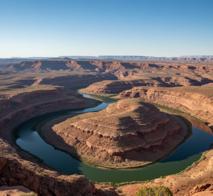
The thing about Goosenecks State Park is that it doesn’t announce itself with billboards or visitor centers crammed with stuffed coyotes. You turn off Highway 163 near Mexican Hat—a town named after a rock that does, admittedly, look like a sombrero—and follow a narrow road for about four miles through scrubland that seems annoyed you’re even there. The San Juan River carved these meanders roughly 300 million years ago, give or take a few epochs, back when this whole plateau was closer to sea level and the river meandered lazily across flat terrain. Then the Colorado Plateau started uplift, and instead of the river finding a new path like you’d expect, it just kept cutting down through rising bedrock, preserving those wild S-curves. Geologists call them “entrenched meanders,” which sounds like something you’d say about a relative who won’t leave after Thanksgiving. The river drops over 1,000 feet in elevation but only travels about six miles as the crow flies, looping back on itself so dramatically that some bends come within a few hundred feet of reconnecting.
Standing at the Edge Where You Realize Your Vertigo Wasn’t Actually Cured by That Therapist
There’s no railing at the overlook. Just you, the void, and about 1,000 feet of air between your boots and the river below. I used to think places like the Grand Canyon were impressive because of sheer scale, but here’s the thing—Goosenecks hits different because of geometry. The meanders twist so sharply that you can see the river disappearing behind rock walls, then reappearing in the opposite direction, then vanishing again. It’s disorienting in a way that makes your brain itch. The rock layers—Pennsylvanian-age limestone, mostly—cut clean across the curves, and you can trace individual strata as they wrap around each bend like pages in a book that someone folded into origami.
Why This Happened Here and Not Literally Anywhere Else That Made More Sense
Turns out the geology had to line up just right. The river established its meandering pattern on soft sediment, probably during the late Paleozoic when this area was swampland or shallow sea—the fossils suggest both at different times, which is confusing but apparently normal for Utah. Then came the Laramide orogeny, that mountain-building event that shoved the Rockies upward and tilted everything in the region. The plateau rose slowly enough—maybe a few millimeters per year, which doesn’t sound like much until you multiply it by tens of millions of years—that the San Juan maintained its course, grinding downward through progressively harder rock. If the uplift had been faster, the river would’ve abandoned those curves and found a steeper gradient. If it had been slower, erosion would’ve widened the meanders into something less dramatic. But it was just right, like geological Goldilocks, and now we have this.
Anyway, the overlook itself is weirdly informal.
The Drive That Feels Like You Took a Wrong Turn But Definitely Didn’t Probably
Highway 261 runs north from the Goosenecks turnoff, and if you’re feeling ambitious—or reckless, depending on your tolerance for unpaved switchbacks—you can take the Moki Dugway, a graded dirt road that climbs 1,100 feet in three miles with grades hitting 10 percent. It was built in 1958 for uranium ore trucks, which explains why it feels like infrastructure designed by someone who lost a bet. From the top, you can see Monument Valley to the south, the Abajo Mountains to the north, and if the light’s right, the Henry Mountains way out west. The Navajo Nation surrounds most of this area, and you’ll pass hogans and sheep more often than other cars. I guess it makes sense that a place this geologically strange would also feel culturally liminal—not quite wilderness, not quite inhabited, but something in between that doesn’t have a tidy category.
What It Feels Like When a Landscape Refuses to Let You Look Away Even Though You Really Need to Pee
Wait—maybe this is the actual point of Goosenecks. It’s not about the river’s patience or the plateau’s stubbornness. It’s about standing somewhere that makes you recieve information your brain doesn’t quite know how to file. The scale’s too big but also too precise. The colors—rust, cream, charcoal—shift depending on cloud cover and time of day in ways that seem almost deliberate, like the rocks are showing off. There’s no sound except wind and maybe a raven if you’re lucky. I’ve been to overlooks with interpretive signs explaining every geological layer and indigenous history and what berries you can eat if you get lost. Goosenecks has a pit toilet and a dirt parking lot. That’s definately intentional, I think—leave people alone with the view and let them work it out themselves. Some landscapes explain themselves. Others just stare back until you get uncomfortable and leave, which is more or less what happened to me after about forty minutes when I realized I’d been standing in the same spot, forgetting to take photos, just watching the shadows move across stone that predates most of the life forms I can name.


