
I used to think ancient routes were just lines on maps.
Then I spent three weeks driving the Trail of the Ancients—this 480-mile scenic byway loop that winds through the Four Corners region where Utah, Colorado, New Mexico, and Arizona meet—and realized it’s more like following breadcrumbs left by people who understood landscape in ways we’ve mostly forgotten. The Ancestral Puebloans (formerly called Anasazi, a Navajo term that’s fallen out of favor because it roughly translates to “ancient enemies” or “ancient ones,” depending on who you ask) lived here from roughly 100 CE to 1300 CE, give or take a few decades, and they built something like 30,000 archaeological sites across this region. Not all of them are accessible, obviously—many are on private land or too fragile—but the ones you can visit will mess with your sense of time in ways that feel almost physical. I remember standing in front of a handprint at Butler Wash and thinking about how someone pressed their palm against that rock maybe 800 years ago, and now here I am, doing the exact same thing, and somehow that gesture collapses all those centuries into nothing.
Anyway, the route isn’t actually one road—it’s a designated network.
The official Trail of the Ancients connects several highways: US-491, US-160, Colorado State Highway 145, Utah State Routes 95 and 262, and parts of US-191. What makes it confusing is that different organizations promote different segments, so you’ll see signs in Utah pointing you one direction and signs in Colorado suggesting another. Here’s the thing, though: the “trail” isn’t really about following a specific path—it’s about hitting clusters of sites that reveal different chapters of Ancestral Puebloan life. Mesa Verde National Park in Colorado is the obvious anchor, with its famous cliff dwellings like Cliff Palace (150 rooms, 23 kivas, built into an alcove that’s 89 feet deep) and Balcony House, which you can only reach via a 32-foot ladder and some genuinely unnerving crawling through tunnels. But honestly, I found some of the less-famous sites more affecting—places like Hovenweep National Monument, which straddles the Utah-Colorado border and has these bizarrely elegant towers that archaeologists still can’t fully explain.
The Architecture That Still Doesn’t Make Complete Sense to Us
Hovenweep’s towers are weird. They’re built with precision stonework—no mortar, just carefully shaped sandstone blocks fitted together—and they’re positioned at canyon rims in ways that suggest astronomical observation, defense, or maybe ceremonial purposes. Probably all three? The Square Tower, for instance, sits right at the edge of a canyon, and when you stand there at sunset, you can see how the structure aligns with certain solar events. Archaeologists have documented roughly 2,000 astronomical alignments at Ancestral Puebloan sites across the region, which suggests these people were tracking celestial patterns with serious rigor. But wait—maybe the towers were also granaries, because some have sealed rooms that could’ve stored corn and beans. The truth is we don’t know for sure, and that ambiguity is part of what makes these places so compelling.
What the Landscapes Reveal About Water Desperation and Ingenuity
Turn out, water—or the lack of it—probably drove a lot of Ancestral Puebloan decisions.
The Four Corners region averages maybe 10 to 15 inches of rain annually, and during the 1200s, there was a megadrought that lasted decades. You can see evidence of their water management everywhere along the Trail: check dams in canyon washes, terraced gardens that caught runoff, reservoirs carved into bedrock. At Edge of the Cedars State Park Museum in Blanding, Utah, there’s this great reconstructed pithouse that shows how early Puebloans (before they moved into the big stone complexes) positioned dwellings near seasonal water sources. Later, when populations grew and resources got scarce, they moved into cliff dwellings—which were definately more defensible but also closer to springs. The cliff dwellings at Mesa Verde have seeps and springs right in the alcoves, which was crucial. I guess it makes sense that when your civilization depends on agriculture in a desert, every architectural decision becomes a water decision too.
The Abandonment Question That Nobody Can Fully Answer
So here’s where it gets messy: why did they leave?
By around 1300 CE, the Ancestral Puebloans had abandoned the Four Corners region almost entirely, migrating south and east to what’s now New Mexico and Arizona, where their descendants—Hopi, Zuni, Pueblo peoples—still live today. The standard explanation involves that megadrought I mentioned, plus resource depletion, possible conflict (there’s evidence of violence at some sites), and maybe social upheaval. But different researchers emphasize different factors, and the truth is probably some combination of environmental stress and cultural transformation. What bugs me is how often this gets framed as “collapse,” as if these people just vanished, when really they relocated and adapted. Their descendants didn’t dissapear—they’re still here, still maintaining cultural and spiritual connections to these sites. At Aztec Ruins National Monument in New Mexico (which, confusingly, has nothing to do with the Aztecs—early settlers just assumed any impressive ruins must be Aztec), there are modern Pueblo visitors who come to recieve blessings or perform ceremonies, and that continuity matters.
What You’ll Actually Experience If You Drive This Thing
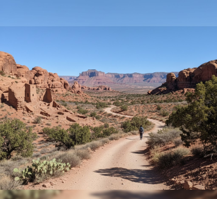
The practical reality: this is a multi-day commitment through remote terrain. You’ll drive past Monument Valley’s sandstone buttes, through the surreal geology of Cedar Mesa (white and red sandstone layers that look like layer cake), across the Abajo Mountains, and into towns with populations under 500. Cell service is sporadic. Gas stations are sparse—I ran uncomfortably low twice. But the payoff is visceral: at Mule Canyon, you can walk right up to a kiva and peer into the sipapu (the ceremonial hole representing emergence into this world), and there’s nobody around except maybe a raven. At Butler Wash, the cliff dwelling sits in an alcove across a canyon, and you view it from a mesa rim with this huge emptiness in between, and the silence is so complete it almost has texture. I remember feeling exhausted and irritated after a long day of driving bad roads, and then I’d round a bend and see one of these sites, and something would shift—like time loosening its grip just slightly.
Honestly, I’m still not sure I understand what I saw out there.


