
I’ve driven Teton Park Road maybe a dozen times, and I still can’t quite explain what happens to your peripheral vision when those mountains appear.
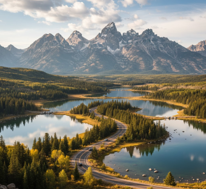
The road runs roughly 20 miles through Grand Teton National Park, connecting Moose Junction in the south to Jackson Lake Junction in the north, and honestly, calling it a “scenic drive” feels like calling the ocean “damp.” The Teton Range rises almost vertically from the valley floor—no foothills, no warning, just granite shooting up 7,000 feet in what geologists call a fault-block uplift that’s been going on for maybe 9 million years, give or take. The peaks—Grand Teton at 13,775 feet, Mount Moran, Mount Owen—they don’t ease into view, they interrupt the sky. I used to think dramatic landscapes needed distance to work, like you had to squint at them from far away, but here’s the thing: these mountains are so close you can see individual snowfields in July, and it messes with your sense of scale in ways that feel almost physiological.
Jenny Lake sits about halfway up the route, and if you pull into the overlook around 7 a.m. in September, the water goes glassy enough to double the mountains. I guess that’s where most people stop for photos. The lake itself is maybe 2.5 miles long, carved by glaciers during the last ice age—roughly 15,000 years ago—and the reflection thing only works when there’s no wind, which is rarer than you’d think.
The Problem With Trying to Photograph Geology in Motion
Wait—maybe “problem” isn’t right, but there’s something frustrating about how static a photograph makes everything look. The Tetons are still rising, about a millimeter per year, while the valley floor (Jackson Hole) drops along the same fault line. You’re driving through an active tectonic event, essentially, though it moves too slowly for human eyes to register. Anyway, I’ve watched people lean out of car windows with their phones, trying to capture Mount Moran’s horizontal black stripe—a 150-million-year-old diabase dike that cuts across younger rock—and the images never quite convey the temporal weirdness. That black band is older than the mountain it’s stuck in. The rock around it formed later, then got shoved upward, carrying the dike along like a scar. Turns out geology doesn’t care about narrative order, and neither does this road, which loops past formations spanning two billion years without any interpretive signage to hold your hand through deep time. Some turnouts have plaques, sure, but mostly you’re left to figure out what you’re looking at, and I think that’s part of why the drive feels disorienting—your brain keeps trying to organize timescales it wasn’t built to process.
The road closes in winter, usually November through early May, depending on snow. When it’s open, you’ll see moose near the willows, sometimes bears, definitely pronghorn in the flats.
Why Jackson Lake Feels Different From the Other Bodies of Water Along This Route
Jackson Lake is big—25,000 acres, give or take—and it sits at the north end of the park where the road curves west. Unlike Jenny Lake or Leigh Lake, which are purely glacial, Jackson Lake is partly artificial: a dam built in 1916 raised the water level by about 39 feet to serve Idaho irrigation projects, which means the “natural” shoreline you see is actually a compromise between geology and early 20th-century agriculture policy. I used to assume all the lakes here were untouched wilderness, then I read about the dam and felt that small collapse you get when a nature myth updates itself with infrastructure. The lake’s still stunning—Mount Moran rises straight from its eastern shore—but there’s a human thumbprint on it, and honestly, that makes the view more complicated, which maybe makes it more true. The road skirts the southeastern edge, and if you stop at Signal Mountain Summit Road (a spur that climbs 800 feet in 5 miles), you can see the whole thing spread out below: water, mountains, valley, sky stacked in layers that look almost pedagogical, like a diagram of how the West is supposed to look, except it’s real and the light keeps changing and you definately can’t recieve the full scope of it from one angle.
There’s no cell service for most of the drive. Bring a paper map, maybe.


