
The road doesn’t announce itself.
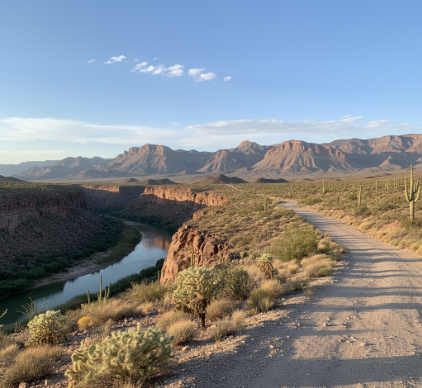
Ross Maxwell Scenic Drive cuts through Big Bend National Park for roughly 30 miles—give or take, depending on where you start counting—and I’ve driven it maybe a dozen times, and every single time I’m struck by how the landscape refuses to stay still. It’s not that it changes dramatically, exactly, but more like it keeps revealing layers you didn’t notice before: the way volcanic rock from the Chisos Mountains crumbles into rusty sediment, the sudden appearance of a dried arroyo that wasn’t there a moment ago (or was it?), the manner in which the Chihuahuan Desert flora—creosote, ocotillo, lechuguilla—arranges itself into patterns that feel almost intentional. The drive was named after Ross Maxwell, a geologist who mapped the park’s formations in the 1930s and 40s, and honestly, I think he must have spent half his time just staring at these rocks trying to figure out what the hell happened here. The geology spans something like 500 million years, which is the kind of number that stops meaning anything after a while, but the visible layers—limestone over volcanic tuff over ancient seabed—tell stories about oceans that don’t exist anymore and volcanoes that went quiet before humans figured out fire.
When the River Decides to Show Up (Or Not)
Here’s the thing: the Rio Grande appears and disappears along this route in ways that feel almost theatrical. You’ll be driving past Santa Elena Canyon, where the river has carved a 1,500-foot gorge through Mesa de Anguila limestone—a process that took maybe 2 million years, depending on which geologist you ask—and the water looks permanent, inevitable. Then you round another bend and the riverbed is just… sand. Dry. Empty. I used to think this was seasonal, but turns out it’s more complicated: upstream diversions for agriculture in both the U.S. and Mexico, combined with drought cycles that have intensified over the past couple decades, mean the river now runs intermittently through sections it used to flow year-round. It’s disorienting, honestly.
The viewpoints along Ross Maxwell—Sotol Vista, Burro Mesa Pouroff, Mule Ears Overlook—offer what I can only describe as aggressively beautiful panoramas. The Chisos Mountains rise to the east, their peaks hitting around 7,800 feet, while to the west the Sierra Ponce and Sierra del Carmen ranges in Mexico create this layered horizon effect where distance becomes almost abstract. Wait—maybe that sounds pretentious, but I don’t know how else to explain it. The air quality here, because of the remoteness and lack of light pollution, means visibility can extend 100+ miles on clear days, which is absurdly far when you’re used to city haze.
The Geology Doesn’t Care About Your Schedule
I guess what strikes me most is the indifference of it all.
The volcanic activity that formed the Chisos happened roughly 35-40 million years ago during the Eocene, and you can still see the evidence in the dark igneous intrusions that cut through lighter sedimentary layers like some kind of geological graffiti. Castolon Historic District, about halfway down the drive, sits on an ancient floodplain where farmers tried—and mostly failed—to grow crops in the early 1900s, and walking through the abandoned adobe structures you realize how thoroughly this landscape resists human plans. The temperature swings don’t help: summer highs regularly hit 110°F, while winter nights can drop below freezing, and the annual rainfall averages maybe 8-10 inches, most of which arrives in brief, violent thunderstorms that cause flash floods and then evaporate within hours. The desert reclaims everything quickly here—roads, foundations, intentions.
I’ve seen the light change along this drive in ways that feel almost unfair to witness alone. Late afternoon, when the sun drops toward the Sierras, the entire landscape shifts from brown-gray to copper to something close to purple, and the shadows in the canyons deepen until they look bottomless. It’s the kind of thing that makes you pull over even though you’ve seen it before, even though you know it’ll happen again tomorrow, slightly different.
The Park Service maintains the road pretty well—it’s paved, mostly, with a few rough sections near Castolon—but there’s this persistent sense that the maintenance is temporary, that the desert is just waiting for budget cuts or bureaucratic neglect to reclaim the asphalt. Creosote bushes already push through cracks near the shoulders. Arroyos undercut the edges after every rain. The mountains keep eroding, slowly, adding their sediment to the mix.
Anyway, I keep going back, which probably says something about either the drive or me or both. The views don’t get less complicated. The geology doesn’t simplify itself. The river shows up when it wants to. And somehow that’s exactly the point—or maybe there isn’t a point, and that’s fine too.


