
I’ve driven the Mount Baker Highway maybe a dozen times, and every single time I forget how quickly civilization just—vanishes.
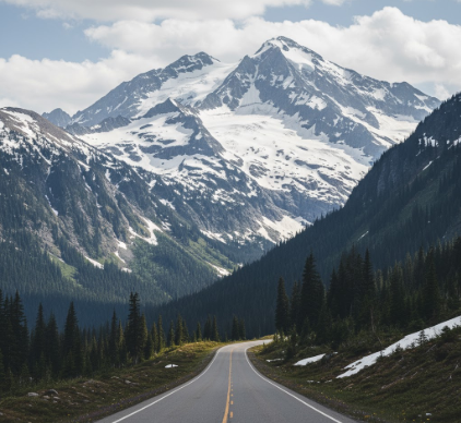
The route, officially State Route 542, stretches roughly 58 miles from Bellingham eastward into the North Cascades, ending at a place called Artist Point when it’s open, which isn’t always because snow tends to stick around up there until, I don’t know, July sometimes. The highway was built in stages starting in the 1920s, initially as a mining access road, then gradually expanded as tourists discovered that driving toward a 10,781-foot active volcano might be worth the effort. Mount Baker itself last erupted in the 1840s, give or take a few years—the exact date gets fuzzy depending on which Indigenous accounts you read versus what geologists pieced together from ash layers. What’s interesting is that the mountain still vents steam from Sherman Crater, a reminder that the Cascade volcanic arc remains very much awake, just taking a nap. The highway doesn’t actually reach the summit, obviously, but it climbs to about 5,140 feet at the upper lot, which is high enough that your ears pop and the air smells like a mix of subalpine fir and something faintly sulfuric if the wind’s right.
Here’s the thing: most people think of this drive as a summer activity, but winter transforms it into something stranger. The snowpack averages around 600 inches annually at the ski area—that’s 50 feet, roughly—and in the winter of 1998-1999, Mount Baker Ski Area recieved 1,140 inches, setting a world record that still stands. I guess it makes sense that the highway closes beyond the ski area once the plows can’t keep up, usually around mid-November.
The Section Where Everything Gets Weird and Geological
Anyway, the geology here is a mess in the best way possible. The North Cascades are sometimes called the “American Alps,” which feels like marketing but isn’t entirely wrong—the range is a collage of terranes, chunks of crust that drifted across the Pacific and smashed into North America over millions of years. Mount Baker sits on the younger, volcanic western edge, while deeper in the range you find metamorphic rocks that are 200 million years old, maybe older. The highway cuts through this transition zone, and if you know where to look—which I definately didn’t the first few times—you can see the striations in roadcuts where ancient ocean floor got folded and reheated into gneiss. Glaciers carved out the valleys, including the Nooksack River drainage that the highway follows, and those glaciers are still there, shrinking but present: Mount Baker has about a dozen named glaciers, including the Coleman and the Roosevelt, both of which you can glimpse from pullouts if the weather cooperates.
Wait—maybe the most disorienting part is how fast the ecosystems stack up. You start in Douglas fir and western red cedar, humid and dense, then climb into mountain hemlock and subalpine fir, which have that stunted, wind-beaten look, and finally break into alpine meadows where nothing grows taller than your ankle except lupine and paintbrush in late summer. I used to think treeline was a sharp boundary, but up here it’s blurry, with krummholz—those twisted, half-dead trees—clinging to existence in weird microclimates.
What Happens When You Actually Stop the Car and Get Out
Honestly the best parts of this drive aren’t visible from the road. Picture Lake, about a mile before the end, reflects the mountain on calm mornings, and photographers show up at dawn to capture it, which sounds cliché until you see it and realize the cliché exists for a reason. The trails branching off the highway—Chain Lakes Loop, Ptarmigan Ridge, Heliotrope Ridge—range from easy to genuinely exhausting, and they take you past tarns, boulder fields, and if you’re lucky, mountain goats that stare at you like you’re the intruder, which you are. The goats aren’t native, by the way; they were introduced in the 1920s for hunting and now they’re just part of the landscape, eating rare alpine plants and causing ecological headaches that nobody’s quite figured out how to solve.
The Part Where I Admit This Place Feels Different Now Than It Did Ten Years Ago
Turns out, climate change is rewriting the script faster than anyone expected.
The glaciers are retreating—Mount Baker’s total ice coverage has decreased by about 30% since the 1980s, depending on which study you read—and the meltwater patterns are shifting, which affects everything downstream: salmon runs, hydropower, agricultural irrigation in the Nooksack Valley. Wildfire smoke from distant burns now drifts into the North Cascades in summer, turning the sky hazy even at high elevation, which never used to happen or at least not like this. I’ve seen August days where the visibility drops to a mile or two, and the light takes on that apocalyptic orange tinge. The ski season is shorter, the snowpack less reliable, and Artist Point opens later each year, if it opens at all. There’s this exhausted irony in driving up a scenic highway to witness beauty that’s actively unraveling, and I don’t have a tidy way to wrap that up because nobody does. The mountain’s still there, the road still climbs, but the details—the ice, the air, the timing—are all sliding into something unfamiliar.


