
I used to think finding a good swimming hole was pure luck—stumbling onto a local’s secret spot or following a trail that dead-ends at shimmering water.
Turns out there’s a whole ecosystem of tools and strategies that people use to track down natural swimming areas, and honestly, once you know where to look, the hard part isn’t finding them—it’s choosing which one to visit first. State and national park websites are the obvious starting point, but they’re also weirdly incomplete because not every natural water access point is officially managed or advertised. Some of the best spots exist in that gray zone between public land and community knowledge, passed down through word-of-mouth or buried in the comments section of obscure hiking blogs. I’ve seen people spend hours scrolling through Google Earth, tracing blue lines upstream, looking for where a creek widens or where satellite imagery shows a break in the tree canopy—classic signs of a potential swimming area. It’s tedious work, but it definately pays off when you find a spot that doesn’t show up on any map.
The Digital Toolbox That Actually Works for Water Hunters
Here’s the thing: apps like AllTrails and Hiking Project have user-submitted photos, and if you filter reviews for keywords like “swimming” or “deep pool,” you’ll uncover places that aren’t officially marked as swim spots. OnX Maps and Gaia GPS let you toggle property boundaries, which is crucial because you need to know if you’re legally allowed to access that gorgeous bend in the river or if it’s surrounded by private land. I guess it makes sense that the most detailed information comes from fishing forums—anglers are obsessive about documenting water conditions, depth, and access points, even if they’re talking about trout instead of swimming. Wait—maybe the best resource is actually local Facebook groups or subreddit communities for specific regions, where people post trip reports with GPS coordinates and warnings about recent algae blooms or water quality issues.
The catch is that these crowdsourced spots can get trashed pretty quickly once they go viral online. I’ve watched places I loved turn into parking nightmares within a single summer because someone tagged them on Instagram with the exact location.
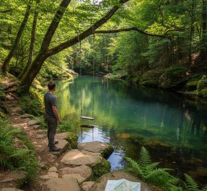
Reading the Landscape Like a Hydrologist Who Forgot Their Field Guide
If you’re willing to do some analog detective work, topographic maps reveal a lot about where swimmable water might hide. Look for contour lines that bunch together near a stream—that usually means a waterfall or a plunge pool. Broader spacing suggests a slower, meandering section that might be too shallow or muddy. Old USGS quad maps sometimes label “swimming area” or “recreation site” in spots that aren’t maintained anymore but still exist if you’re willing to bushwhack a bit. I used to think geology didn’t matter much, but limestone and granite landscapes tend to produce clearer water and better-defined pools compared to areas with clay or sedimentary rock that clouds everything up. Seasonal timing matters too—spring runoff can make a swimming hole dangerously fast, while late summer might reduce it to a stagnant puddle breeding mosquitoes.
Anyway, talking to park rangers or staff at outdoor gear shops often yields better intel than any app.
The Unspoken Rules and Real Risks Nobody Wants to Mention Until Someone Gets Hurt
Natural water access comes with hazards that don’t exist in a chlorinated pool, and it’s weirdly easy to underestimate them because the setting feels so peaceful. Cold shock can incapacitate even strong swimmers within minutes if the water temperature is below roughly 60 degrees Fahrenheit, give or take—mountain-fed streams stay frigid even in July. Submerged rocks, sudden drop-offs, and currents that aren’t visible from shore account for a significant portion of drowning incidents in natural swimming areas, according to data from the CDC and various state health departments. Water quality is another issue that’s harder to assess without testing: agricultural runoff, animal waste, and harmful algal blooms can all make a picturesque swimming hole a source of gastrointestinal illness or skin infections. Some states maintain online databases where you can check recent water quality test results for popular swimming areas, but plenty of informal spots never get tested at all. I guess the safest approach is to look for moving water rather than stagnant, avoid swimming after heavy rains when runoff peaks, and never dive into water unless you can clearly see the bottom. Also—and this should be obvious but people ignore it constantly—if there’s a “No Swimming” sign, it’s usually there because someone already learned the hard way that the spot is dangerous, whether from pollution, hidden hazards, or unsafe access. Respecting private property and leave-no-trace principles isn’t just ethical; it’s what keeps these places accessible for everyone else who comes after you.


