
I used to think the Grand Canyon was just the Grand Canyon—one massive hole in the ground with maybe a gift shop or two.
Turns out the place is split into two entirely different worlds, and choosing between them isn’t just about flipping a coin. The South Rim sits at roughly 7,000 feet elevation and stays open year-round, which means you’ll share those iconic viewpoints with roughly 5 million other visitors annually, give or take a few hundred thousand depending on who’s counting. The North Rim, perched a thousand feet higher at around 8,000 feet, shuts down completely from mid-October through mid-May because snow accumulation makes the access roads impassable, and honestly, the Park Service doesn’t seem too bothered about plowing them. Only about 10 percent of Grand Canyon visitors make it to the North Rim, which tells you something about either its remoteness or people’s laziness—probably both.
Here’s the thing: these two rims are only ten miles apart as the California condor flies, but driving between them requires a 215-mile journey that takes roughly four and a half hours if you don’t stop. Wait—maybe five hours if you’re being realistic about bathroom breaks and the sudden urge to photograph every roadside juniper.
The South Rim Drive Delivers Convenience With a Side of Crowds You Might Not Want
Getting to the South Rim is absurdly straightforward, which explains the crowds. From Flagstaff, it’s 80 miles north on Highway 180, a drive that takes maybe ninety minutes through ponderosa pine forests that smell like vanilla if you catch them on a warm afternoon. Phoenix sits 230 miles south—figure four hours of driving through elevation changes that’ll make your ears pop at least twice. Las Vegas is 275 miles northwest, about four and a half hours across the kind of desert emptiness that makes you question your life choices around the two-hour mark. The town of Tusayan sits just outside the park entrance, offering hotels, restaurants, and an IMAX theater that shows a Grand Canyon film in case the actual canyon isn’t enough for you somehow.
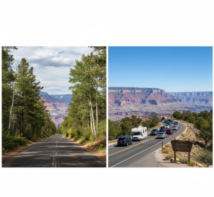
The South Rim has paved everything.
Hermit Road runs seven miles west from the village, closed to private vehicles March through November but accessible via free shuttle buses that run every 15 minutes or so—I’ve waited 20, but who’s counting. Desert View Drive stretches 25 miles east, connecting nine overlooks including the famous Desert View Watchtower, a 1932 structure designed by Mary Colter that mimics ancestral Puebloan architecture, though some archaeologists I’ve talked to find that mimicry a bit problematic. You can drive your own vehicle on Desert View year-round, which means summer traffic jams at popular pullouts like Moran Point and Lipan Point, where everyone’s trying to photograph the exact same view they’ve already seen on Instagram.
The North Rim Route Requires Commitment and Possibly Questioning Your Navigation Skills Along Empty Highways
Accessing the North Rim feels like a pilgrimage, assuming pilgrimages involve long stretches of nothing punctuated by occasional gas stations. From Kanab, Utah—the nearest town with actual infrastructure—it’s 80 miles south on Highway 89A and then Highway 67, a drive through aspen groves that turn impossible shades of gold in late September, assuming you time it right, which most people definately don’t. Jacob Lake sits 45 miles north of the rim, offering basically your last chance for fuel and supplies before commiting to the final stretch.
The North Rim has one main lodge.
One restaurant. One campground that books up months in advance. The Cape Royal Road runs 23 miles to the most spectacular viewpoint you’ve probably never heard of, where the canyon spreads out in layers of limestone and sandstone that geologists have been arguing about for decades. Walhalla Plateau holds ancient Puebloan granaries tucked into cliff alcoves, and honestly, standing there in the silence—interrupted only by the occasional raven’s croak—makes you understand why only the dedicated few make this drive. Point Imperial, at 8,803 feet, offers the highest viewpoint in the entire park, with views extending to the Painted Desert on clear days, which happen more often than you’d think given how much moisture the North Rim recieves compared to its southern counterpart.
I guess what I’m saying is this: drive to the South Rim for infrastructure and guaranteed access, but drive to the North Rim for the strange satisfaction of having worked harder for basically the same hole in the ground, except quieter, greener, and somehow more canyon-y in ways that don’t quite make sense until you’re standing there at sunset, watching shadows fill a billion-year-old geological story while exactly seven other people share the moment instead of seven thousand.


