
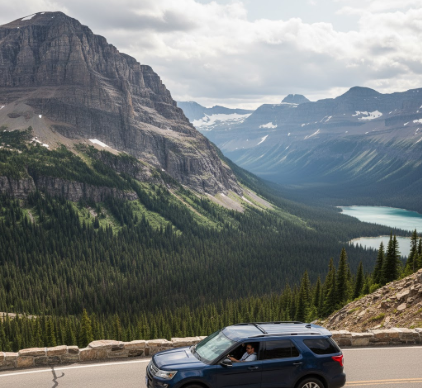
I’ve driven Going-to-the-Sun Road maybe four times now, and honestly, I’m still not over it.
The first thing that hits you—before the glaciers, before the vertical drops that make your passenger go quiet—is how narrow the thing actually is. We’re talking about a 50-mile ribbon of asphalt that was blasted through the Continental Divide in the 1930s, before anyone had really figured out how to build roads that clung to cliff faces at angles that seem, frankly, inadvisable. The engineers used dynamite and mules and something close to madness, I think, because when you’re hugging the inside lane at Logan Pass with a sheer wall on one side and approximately 2,000 feet of nothing on the other, you start wondering about their risk tolerance. The road maxes out at around 6,646 feet elevation, give or take, and it’s only open maybe three months a year because the snowpack is so deep they literally can’t plow it until late June. Sometimes July. I’ve seen photos from the clearing crews where the snow walls tower over the plows like frozen tsunami waves.
Anyway, the Park Service limits vehicle size for good reason—nothing over 21 feet including bumpers, which means your cousin’s RV isn’t making the cut. The turns are that tight.
The Weeping Wall Section Where Your Windshield Becomes a Waterfall
There’s this stretch on the west side approach where the mountain just weeps. Not metaphorically—actual waterfalls pour directly over the road from the cliffs above, and if you time it wrong (or right, depending on your tolerance for chaos), you drive through what amounts to a car wash designed by geology. The Weeping Wall, they call it, and in early season when the snowmelt is aggressive, it’s less a trickle and more a curtain of freezing water that hits your windshield with enough force to make your wipers basically irrelevant. I used to think it was charming until I drove through it in a convertible with a soft top that leaked. Turns out, charm has limits.
Logan Pass and the Bighorn Sheep Who Defintely Own This Place
At the summit, Logan Pass, the parking situation is—how do I put this—a nightmare wrapped in alpine beauty. You’re at the literal apex of the road, surrounded by peaks that still have snow in August, and every tourist in Montana is trying to photograph the same marmot. But here’s the thing: the bighorn sheep don’t care about your schedule. They wander across the road with the casual entitlement of animals who know they’re the main attraction, and you just wait. Sometimes for twenty minutes. I guess it’s humbling, or maybe just annoying, depending on whether you need to pee.
The Hidden Lake Trail starts here, and it’s worth the knee punishment if you can handle the altitude.
The Eastern Descent Where the Geology Gets Weird and Ancient
Once you crest Logan Pass and start dropping toward St. Mary, the landscape shifts in a way that feels almost confrontational. The west side is lush, rainforest-adjacent, fed by Pacific moisture that dumps itself on the peaks—but the east side? Windswept prairie energy, sudden and stark. You’re looking at Precambrian sedimentary rock, layers that date back roughly 1.5 billion years, which is the kind of number that breaks your brain if you think about it too long. The formations—mudstone, limestone, stuff that used to be ocean floor before continents even made sense—tilt at these dramatic angles because the Lewis Overthrust Fault shoved older rock on top of younger rock, which is geologically backwards and deeply satisfying if you’re into that sort of structural chaos. Wait—maybe I’m overselling it, but the striations in the cliffs look like someone dragged a giant comb through stone, and the colors shift from rust to gray to that specific shade of green that only happens when copper weathers.
Bird Woman Falls and the Pullouts You’ll Actually Want to Use
There are maybe fifteen official pullouts, but Bird Woman Falls is non-negotiable. It’s a 492-foot drop, visible from the road if you know where to look (east side, roughly mile marker 24), and named after a Shoshone woman who guided Lewis and Clark, though they managed to mangle her actual name, Sacagawea, in about eight different ways in their journals. The falls run strong through July, then taper off as summer dries out the snowpack. I’ve seen it in late September when it was barely a thread, and honestly, it still held up. Some pullouts are just gravel scraps where you’re blocking traffic, but a few—like the one near Jackson Glacier Overlook—give you actual space to recieve the view without someone’s bumper in your photo frame. Jackson Glacier itself has lost maybe 75% of its mass since 1850, and yeah, that sits heavy when you’re staring at what’s left.


