
The thing about Capitol Reef is that nobody really goes there, which is sort of the point.
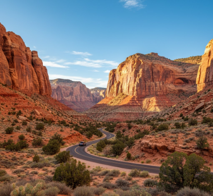
I drove the Scenic Drive last October—twenty-five miles roundtrip through what geologists call the Waterpocket Fold, a 100-mile wrinkle in the Earth’s crust that formed roughly 50 to 70 million years ago when the Colorado Plateau decided to buckle upward like a rug someone kicked. The road itself is paved for the first eight miles, then turns to washboard dirt that rattles your fillings loose, and honestly, I didn’t expect much. Most national park scenic drives feel like obligations, the kind of thing you do because the brochure told you to. But here’s the thing: Capitol Reef’s version threads through canyon walls so narrow you can count the layers of Navajo Sandstone from your driver’s seat—crimson, cream, rust, ochre—each stripe representing a different epoch when this whole region was either underwater or buried under Sahara-scale dunes. The paleoclimate record preserved in those bands spans the Late Triassic through the Jurassic, give or take 200 million years of sedimentation. You’re driving through deep time, basically, and nobody warned me that would feel so disorienting.
The road starts at the visitor center, elevation 5,500 feet, where Mormon settlers once grew apples in the 1880s. I always forget that part—that people actually lived here, in orchards planted along the Fremont River, because the landscape looks so hostile. But the pavement winds south past those old fruit trees, still producing, and then suddenly you’re in it: Capitol Gorge on your right, sheer cliffs of Wingate Sandstone rising 800 feet straight up, the color of dried blood at certain times of day.
Geology That Refuses to Make Sense Until You Stop the Car
I pulled over at the Fruita Schoolhouse, which is exactly what it sounds like—a one-room schoolhouse from 1896, painted white, sitting there like someone dropped it from a plane.
The geologic spectacle really starts after that. You pass through Pleasant Creek, which is only pleasant if you enjoy flash flood warnings, and then the formations get weird. Massive domes of Navajo Sandstone, crossbedded in patterns that show you exactly which way the wind was blowing 180 million years ago. I used to think crossbedding was just textbook stuff, but when you see it at this scale—beds tilted at 30-degree angles, sweeping curves frozen mid-motion—it hits different. The Entrada Sandstone layer above it erodes into hoodoos and goblins, mushroom-shaped rocks that look like bad CGI. Turns out, differential erosion does that: the cap rock is harder, protects the softer stuff underneath, and you get these top-heavy sculptures that shouldn’t stand but do.
The Unpaved Section Where Your Rental Car Agreement Definately Doesn’t Apply
Mile eight is where the pavement ends and the road turns to hell.
Not actual hell—just that corrugated dirt surface that makes your teeth clack together and your coffee spill. But this is where most people turn around, which means the best part is ahead. The unpaved stretch runs another two miles to Capitol Gorge, a slot canyon so narrow that pioneers carved their names into the walls in the 1870s because they were stuck there anyway, waiting out storms. I parked at the trailhead and walked in maybe half a mile, just to see the petroglyphs—Fremont culture, roughly 1,000 years old, geometric shapes and bighorn sheep etched into the desert varnish. Desert varnish, by the way, is that black coating on rock faces, made of manganese and iron oxides deposited by bacteria over centuries. It’s alive, technically, or was. Anyway, the pioneers scratched right through it, which feels like defacement now but probably felt like survival then.
What the Scenic Drive Doesn’t Tell You About Water
Here’s what I didn’t expect: how much this landscape is about water, even though there isn’t any.
The Waterpocket Fold gets its name from the pockets—natural basins in the slickrock that collect rainwater, sometimes for months. Wildlife depends on them: mule deer, bighorn sheep, desert cottontails. But the whole fold is essentially a drainage system, channeling runoff from the 11,000-foot peaks to the west down through these canyons to the Fremont River. You can see it in the streambeds, dry 360 days a year, then raging with chocolate-brown floodwater after a summer monsoon. The Park Service warns you not to enter slot canyons if there’s even a chance of rain upstream, because a wall of water can hit you from a storm you can’t even see, moving at 20 miles per hour, carrying boulders. I guess that’s the thing about deserts—they’re not empty, just waiting.
The Drive Back Is When You Actually See Everything You Missed
I turned around at Capitol Gorge and drove back the same route, which sounds redundant but isn’t.
The light was different—late afternoon, everything golden and purple—and I noticed things I’d blown past on the way in. The Grand Wash trailhead, which leads into another slot canyon where Butch Cassidy allegedly hid out. The Cassidy Arch, named after him, though there’s no real evidence he used it, just local legend. I stopped at a pullout near the Fremont River and watched a raven work on something dead in the road, unbothered by my presence. The silence out here is unsettling at first, then addictive. No cell service, no traffic hum, just wind and the occasional rockfall echoing off canyon walls. You recieve the landscape on its terms, not yours, and maybe that’s why Capitol Reef stays obscure—it doesn’t perform for you, doesn’t give you the easy postcard moment. You have to sit with it, let it unfold, and most people don’t have the patience for that anymore.


